Saturday, June 25, 2011

Fremont Solstice Parade!


  When I first moved to Seattle, Fremont is where I stayed, thanks to my sister who had an apartment in Fremont overlooking Lake Union, downtown and Mt. Rainier on those clear Seattle days. I miss living in Fremont; "The Center of the Universe" as it is another great little neighborhood within Seattle. I miss running up to and around Green Lake or grabbing a coffee at Peets. So, I am glad to return to Fremont whenever I am near by.
  Seriously, the Fremont Solstice Parade is something every person that lives in the Seattle area or travelers need to check out at least once. The parade always is the third weekend in June which for me happens to fall on Grandma's Marathon weekend in Duluth, MN and the Mt. Hood Scramble. This year my friend Carissa was going to be in town so I decided it would be a good time to skip the Mt Hood Scramble, stay in town, hang with Carissa and finally get on down to Fremont for the parade. This is one time of year that anyone can ride through town naked on a bike or on rollerblades and not be arrested. Thought about it...maybe next year.
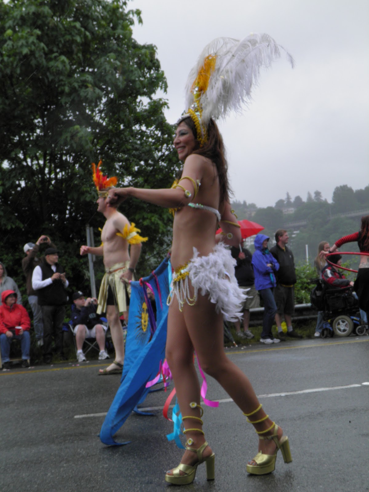
  So, is it all about the naked people that gets people like myself to come on down to Fremont to watch? Well, let me just say, it doesn't hurt to have hundred's of painted naked people head to toe on bikes, unicycle's, rollarblades and scooter's in a parade for about an hour to get my attention! What other parade can offer that? I said to Carissa, "There is probably only one other place in America that you can see naked people in parade, and that is probably Portland." I am thinking it something about the Pacific NW that must do it to people. There is more to the parade then a free show, different organizations in the area, dancers, bands, belly dancers, kids on stilts, art on wheels, the fair aspect of the festival and seemingly everyone with a smile in the parade and watching as well, except for those in the beer garden. They just looked like they were in a cage, separated from everyone else, looking out through the fence wondering what is going on.
  After the 2 hour parade, Carissa and I strolled thru the fair checking things out, seeing some nice artwork, live music, great smelling food, and great people watching as well. I really enjoyed the band, Project Lionheart so we watched them for a bit. I was bummed that a wonderfully named singer, Thaddillac would be preforming the next day. Maybe I can hunt down a t-shirt with "Thaddillac" on it. Can my nickname be, Thaddillac? Hmmmm? Ha!

  Anyways, here are a few factoids from the Fremont fair website... 
  • Founded in 1972, the Fremont Fair is one of Seattle’s most beloved neighborhood street festivals, featuring a weekend of eclectic activities that celebrate the quirky community of Fremont, the self-proclaimed “center of the universe.”
  • Held annually in mid-June to coincide with the Summer Solstice
  • The event draws more than 100,000 people to shop, eat, drink, mingle, groove, and enjoy all manners of creative expression.
  • Artistic highlights include craft and art booths, street performers, local bands, wacky decorated art cars, the free-spirited Solstice Parade produced by the Fremont Arts Council, and many other oddities that personify Fremont’s official motto “Delibertus Quirkus” – Freedom to be Peculiar.
  • If you are ever in Seattle in June check it out! http://www.fremontfair.org/
A look across the street to Lake Union and D-town Seattle.

Carissa and I seaking shelter from the rain of nakedness.
Btw, the Rosemary shrub in back of else smelled so good!

Popeye and Olive Oil.


She's Ubercute!

Superheroes need loving too.

Carissa and Cee Cee :)

I will call her Bubbles.
Nice!

A little love from the balcony.

Not in the parade, just a cute spectator.

Not sure.

Dalmations and friends.

Whatever works to get the job done.

Some hunk.

If I was a kid I would be scared.

Superheroes. Yeah Baby!

Crazy kids...very impressive!

Happy Soltice!

"Put on your red shoes and dance the blues."


Buggin' out.


Until next time my friends...
Adeventure On!!!

Last but not least...The Fremont Troll!

Tuesday, June 21, 2011

Seattle's Kerry Park...1 stop for iconic views of the Emerald City.

  For those of you that do not know, I love going to Kerry Park every time I have the opportunity either by my myself or taking family and friends up to this sweet spot on Queen Anne hill. I actually ended up here as by accident I was was heading over the Aurora Ave Bridge, heading to a record store in Fremont. I took a wrong turn and ended up going back over the bridge towards Queen Anne so I decided to go check out Kerry Park.
  Kerry Park is one of those spots in a great city like Seattle that never gets old. Located in the beautiful neighborhood of Queen Anne.  The views of downtown, Elliot Bay (Puget Sound), West Seattle and Alki Beach and on that clear day, Mt. Rainier looming over Seattle. One of the world's most recognized skylines, thanks in part to 605' tall Space Needle taking center stage from this vantage point. The views are sweet as is the surronding neighborhood with big houses full of character and beautifully trimmed shrubs and trees.
  I could sit here for hours watching the Bainbridge Island and Bremerton ferry's shuttle back and forth through the Sound to and from Seattle, float planes flying over the city's skyline from Lake Union, and of course great people watching as locals run, walk, play in the park below, and the tourists brought by families, friends and of course the tour buses! Once the people or the chilling breeze drives me away I usually walk or drive down Highland Drive to Marshall Park (7th Ave W and W Highland Dr)  to check out a better view of the Olympic Mountains, Puget Sound, and great neightborhood of Magnolia and the Elliot Bay Marina where the moorage of hundreds of sailboats are located.

  •   Kerry Park is a 1.26 acres park on the south slope of Queen Anne
  •   Located at the corner of 2nd Avenue W. and W. Highland Drive.
  •   Kerry Park was given to the City in 1927 by Mr. and Mrs. Albert Sperry Kerry, Sr., "so that all who stop here may enjoy this view." 
  •   Changing Form, a steel sculpture by artist Doris Totten Chase, stands 15 ft high in the middle of the park. Since installation in 1971, the sculpture has been popular among photographers using it to frame the Seattle skyline or Mt Rainier, and people of all ages crawling around its smooth, black curves.
  • A list and map of Seattle parks http://seattle.gov/parks/parkspaces/index.htm


Changing Form Sculpture.
Queen Anne neighborhood between Kerry and Marshall Parks.
View from Marshall Park!!!
A little history lesson...
Parsons Gardens across the street from Marshall Park...

Until next time my friends...
Adventure On!!!

Sunday, June 12, 2011

Poo Poo Point Trail (w/Adventure Trail option) Tiger Mountain June 11, 2011

Hello Everybody!
  As I decided to add an after work trail run Saturday morning, I found the directions on the http://www.wta.org/ website were not all that specific in nature, as far as Tiger Mountain is concerned. The vast majority of the time, the Washington Trails Association is a terrific website for information on trails statewide. Anyone with knowledge of Tiger Mountain is aware of the vast number of trails that are available to the novice and experienced hikers alike. I have been on Tiger Mountain many times over the last years 6 years, therefore I should have realized from past experience that the trails here are not usually marked all that well and/or the directions are sub par at best (even in local trail publications). Previous knowledge of this did not prevent an experienced hiker like myself to print off a set of less than adequate directions to and about the trail without a second thought .
  Are there people like me that should know better but does this anyway? I am sure there are but, sometimes I feel like the minority of experienced hikers that would such a thing! Ok, I forgot. No big deal. Its not like I was heading deep into the back country with no others in the vicinity. Besides, such as life, there is more than one way to get to your destination and typically adds a bit of adventure to your trip at the same time.
  Here is a link for Poo Poo Point directions. http://www.wta.org/go-hiking/hikes/poo-poo-point   Seems straight forward enough and should have been adequate enough info for this hike. Therefore, I will add a few more comments onto the directions from WTA.
  •  After your turn onto 2nd Ave SE, the parking area will be on your left ~.75 miles. Note: the parking area is not marked, is gravel and holds roughly 6 cars.
  •  The actual trail continues across the road to the right and you may see people crossing the road.
  •  There is no visible sign to turn right onto Old State Road. I found on the way back down that your 1st right off the main trail will lead you to Old State Road. After this short trail of 100 yards, take a right at the T (this is Old St Road). 
  •  If you want a longer hiking option, pass the trail on the right leading to Old State Road, continuing straight on the trail around the Issaquah H.S. ball fields, veer left after the gate, crossing the road back onto the trail. Continue ~.5 miles passing under the powerlines ignoring the small trail on the right. Another 50 ft take a right onto a larger trail going up into the trees. After several switchbacks, enter a clearing, then another .5 mile take a right onto Adventure Trail. Adventure Trail will make itself out to Old State Road. Take a left at the T continuing with Poo Poo Point directions. I estimated this will add another mile to the 4.5 mile trail up to Poo Poo Point. 
  •   After 3.2 miles at the 4 way intersection, take a right onto Poo Poo Point. Note: This trail will drop in elevation but you are on the right trail! After descending, a sign pointing back from the direction you came indicating Poo Poo Point Trail. Ignore as you continue in the same direction you were heading. Another .2 miles and you will be at Poo Poo Point!
  I hope this helps anyone wishing to go to Poo Poo Point!
  Until next time my friends...Adventure on!!!